
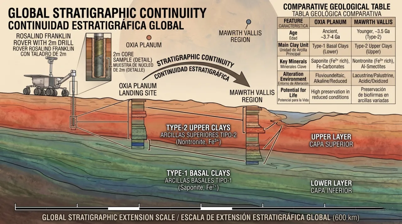
A 600-kilometer geological cross-section showing Mars' clay layers like a cybernetic wedding cake. Ideal for convincing anyone that looking for reduced life is much more sophisticated than a simple excavation.
The quest for answers about Mars' past inevitably leads us to the crustal dichotomy, the gigantic geological boundary that divides the southern highlands and the northern lowlands of the red planet. Within the southern sector of the Chryse Planitia basin lies one of the oldest and most fascinating sedimentary records in the entire solar system, originated during the Noachian period between 4.1 and 3.7 billion years ago. In this remote epoch, the planet experienced vigorous magmatic activity and large-scale aqueous alteration. Beneath the present floor of this basin, geophysical data conceals an ancient buried impact basin about 1090 kilometers in diameter —a colossal circular footprint from the past— which underwent intense structural modification before finally stabilizing.
Over eons, erosion caused the highland scarp front to retreat south-southeastward over hundreds of kilometers. This geological dismantling fragmented the original plateau into thousands of isolated, kilometer-scale mounds north and west of Mawrth Vallis. Curiously, these mounds have functioned as genuine stratigraphic windows and time capsules. By acting as a prolonged natural shield against destructive solar and cosmic ionizing radiation, these landforms protected the clay deposits of the adjacent Oxia Planum plains. Thanks to this protective roof, which has only recently been removed by relentless wind erosion, subsurface phyllosilicates and potential organic compounds have remained safe from the harsh Martian environment.
A six-hundred-kilometer geological highway
A comprehensive study published in the scientific journal Icarus by a team led by Inés Torres Auré from the University of Lyon has revolutionized our understanding of this region. By analyzing data from ESA's Mars Express and NASA's Mars Reconnaissance Orbiter spacecraft, researchers have demonstrated that a large-scale stratigraphic continuity exists between the landing site of ESA's Rosalind Franklin rover in Oxia Planum and the sedimentary region of Mawrth Vallis, located some 300 kilometers away. Both areas are part of a continuous stratigraphic sequence that extends over a length of more than 600 kilometers and exceeds one kilometer in vertical thickness. This challenges previous theories suggesting the existence of small, isolated local sedimentary basins, proving that we are witnessing a geological phenomenon of planetary magnitude.
To unravel the nature of these immense deposits, scientists combined spectral maps with high-resolution optical imagery, successfully differentiating two dominant clay signatures designated as Type-1 and Type-2. The basal Type-1 clay unit —characteristic of Oxia Planum— is composed of magnesium-rich smectites, ferrous saponite with divalent iron, and vermiculite-type phyllosilicates. This mineralogical combination tells us of ancient alkaline or neutral aqueous environments with very low water turnover, where iron remained in a reducing chemical state. To imagine it simply, this basal layer was the equivalent of thick, stagnant mud at the bottom of a poorly ventilated lake. Spectrally, this Type-1 is betrayed by very specific absorption bands between 2.308 and 2.312 micrometers and signatures associated with calcium and iron carbonates, such as siderite and magnesite.
Overlying this basal bed sits the Type-2 clay unit —typical of Mawrth Vallis—, consisting mainly of ferric iron-rich nontronite, aluminum smectites like montmorillonite and kaolinite, as well as amorphous silica. Here, the chemical plot twisted: the presence of this oxidized iron reflects a transition toward much more leached, oxidizing, and neutral to slightly acidic environments. If the lower layer was stagnant mud protected from oxygen, this upper layer is equivalent to the reddish, rain-washed soils found today in Earth's tropical regions. In the spectrum, this unit is clearly distinguished by absorption bands centered at shorter wavelengths, specifically at 2.29 and 2.20 micrometers.
Scars in time and the mystery of water
The three-dimensional architecture of these deposits confirms that the Oxia Planum clays are located exactly below the Mawrth Vallis sequences. However, the contact between the two units does not occur gradually. Between Type-1 and Type-2 appears a cratered, dark, and fractured paleosurface that belongs entirely to the basal unit's signature. This boundary represents an ancient landform that remained exposed to cosmic weathering and meteorite bombardment for a prolonged period before being buried by Type-2 clays. The sedimentary record of Chryse Planitia reveals two of these major geological interruptions or hiatuses: the internal Oxia Planum paleosurface, dated at about 4.0 billion years ago, and the Oxia-Mawrth transition paleosurface, which formed between 4.0 and 3.7 billion years ago. These pauses prove that Mars' climate was not a continuous body of water, but was interrupted by long periods of cold, extreme aridity where sediment accumulation stopped completely.
This colossal volume of phyllosilicates sparks an intense debate about what kind of aqueous agent originated them, forcing scientists to evaluate different paleohydrological models. The stable continental water body model —such as a deep ocean— proposes that a gigantic water body covered the Martian dichotomy 4.0 billion years ago. However, this approach clashes with physics, as the deposits span an elevation difference of more than 1300 meters, which would require shoreline elevations at implausible heights. On the other hand, the episodic flooding model via deep aquifers suggests the presence of massive, violent surges of water flooding the plains, but this contradicts the vast uniformity of the layers and the absence of chaotic textures at the base.
Because of this, the model gaining the most traction is supergene weathering or pedogenesis, meaning the in situ alteration of basaltic rock by rain and climate in a warm, humid environment. The clay profiles in the region show a vertical sequence where the more mobile aluminum is systematically positioned above iron and magnesium. With an average thickness of 59 meters, these profiles are identical to terrestrial tropical soils and would have required between 0.2 and 8 million years of stable humid climate to form. From a chemical standpoint, rainwater dissolved the magnesium from the basal Type-1 saponites, enriching the solid residue in iron until it transformed into Type-2 nontronites. Curiously, this climate evolution has a double astrobiological edge: while the reducing and neutral environment of Type-1 is ideal for long-term biomarker preservation, the oxidizing and acidic environment of Type-2 tends to destroy complex organic molecules.
A scientific drill to break records
With this geological roadmap in hand, the mission of ESA's Rosalind Franklin rover takes on a completely new dimension. Following the reconfiguration of its schedule to be launched in 2028 and land at Oxia Planum in 2030, the vehicle will not explore an isolated local outcrop, but the base of a global climate system. To fulfill the ambitious goal of searching for biosignatures, the rover's key component is its high-precision subsurface drill. This instrument is capable of engaging three extension rods to penetrate up to a record depth of 2 meters beneath the destructive Martian regolith, a location where biological samples are safe from radiation and surface oxidation.
Drilling operations will be organized into two strategic modalities. On one hand, Experiment Cycles will be conducted to collect surface and subsurface samples at six points of high geological interest. On the other hand, Vertical Soundings will be reserved for the two most promising sites, performing systematic drilling and analysis every 50 centimeters of depth until reaching the 2-meter limit. This latter modality will provide a continuous stratigraphic profile of high vertical resolution with a total of 20 analyzed samples, allowing us to read Mars' past page by page, as if turning the leaves of an Earth history book.
At a depth of two meters, the environment at Oxia Planum is harsh and frigid, with average temperatures of minus 60 degrees Celsius and pressures of just 6 to 7 millibars. In this scenario operates the Ma_MISS instrument, a miniaturized spectrometer installed inside the drill tip itself that analyzes the borehole walls natively before sample extraction. This step is crucial to study minerals in their real state, preventing them from magnifying or undergoing loss of water through frost-desiccation upon contact with the dry atmosphere of the rover's analytical laboratory. Earth-based testing with the SOPHIA analog soil demonstrates that these smectite- and gypsum-rich clays retain their water excellently for over 72 hours under Martian conditions. These basal Type-1 clays act as perfect physical and chemical protectors, blocking the photochemical degradation of sensitive molecular biosignatures, such as the amino acid L-histidine, ensuring that if life left its mark on early Mars, ESA's drill will have a real chance of finding it in 2030.