
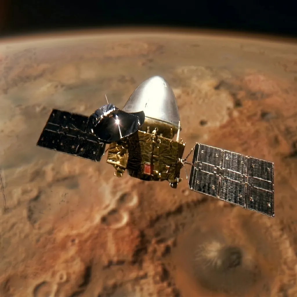
Tianwen-1
The CNSA Tianwen-1 orbiter consolidated independent Chinese exploration at Mars, operating stably into 2026. Key achievements include the 76 m true-color global orthomosaic map, the MTW120 global gravity model, and the detailed three-dimensional capture of the interstellar comet 3I/ATLAS.
Agency

Country

Type
Orbiter
Status
Launch
July 23, 2020
COSPAR Designation: 2020-050A
Official Names: Tianwen-1 Orbiter
Responsible Space Agency: China National Space Administration (CNSA)
Launch Date and Time: July 23, 2020, 04:41 UTC
EDL / Orbital Insertion Date and Time: February 10, 2021, 11:52 UTC (Martian orbital insertion)
Landing Site / Coordinates: Not applicable to the orbiter (Operations from elliptical polar orbit)
Launch Vehicle: Long March 5 Y4
Current Mission Status: Operational (Extended mission phase active into 2026)
1. Historical Context and Detailed Objectives
The Tianwen-1 mission represented the first independent foray of the China National Space Administration into deep martian space. The Chinese planetary program designed this architecture to resolve an unprecedented technological challenge: executing orbital insertion, atmospheric descent, soft landing, and surface vehicle deployment within a single launch window. The scientific void it aimed to fill lay in the necessity of obtaining a global, continuous, and high-resolution characterization of the martian environment, as well as establishing a stable telecommunications infrastructure on the red planet.
The primary objectives of the orbiter focused on global geological characterization through optical and radar remote sensing, surface mineralogical composition analysis, the study of the martian ionosphere and magnetosphere, and the estimation of the gravitational field. As secondary objectives, the platform assumed the role of an exclusive high-speed telecommunications relay station to retransmit data generated by the Zhurong rover and, following its hibernation in May 2022, diversified its objectives during an extended mission phase toward astrophysical observations of interstellar objects and high-resolution geodesy.
2. Vehicle Architecture and Main Subsystems
The orbiter, developed by the China Aerospace Science and Technology Corporation together with the Shanghai Academy of Spaceflight Technology, possesses a combined dry structure and propellant mass ranging between 3175 kg and 3715 kg. The modular structure is configured around an octagonal central bus that provides the necessary structural rigidity to tolerate mechanical stresses during hyperbolic braking. The electrical power supply depends on two large steerable solar arrays equipped with high-efficiency gallium arsenide cells, calibrated to operate under the low solar radiation flux in Mars orbit, equivalent to approximately 1.52 astronomical units.
The main propulsion system consists of a 3000 N vacuum thrust chemical bipropellant engine utilizing nitrogen tetroxide and monomethylhydrazine as hypergolic propellants. This system is responsible for major velocity change maneuvers, complemented by a redundant network of small 25 N chemical thrusters for three-dimensional attitude control and fine adjustments. To assess its status autonomously, the orbiter integrates the Mars Orbiter State Monitoring Sensor, equipped with a self-deploying articulated arm 1.6 meters in length and 0.8 kg in mass made of shape-memory composite materials that expand via solar heat absorption. The telecommunications system uses X-band for direct links between Earth and the orbiter, and UHF and X-bands for interconnection with assets on the martian surface.
Anchoring analogy for attitude control and telecommunications
Attitude control and modulation of bit rates in deep space work similarly to a lighthouse keeper trying to communicate with a distant ship in the middle of a storm using a signal mirror. The keeper must keep their body firmly supported and make millimeter movements with their arms so that the reflected beam points accurately at the ship without drifting due to the wind; in turn, if the ship moves too far toward the horizon, the keeper must make the light signals slower and more spaced out to ensure the receiver distinguishes each flash clearly without distance distorting the message.
3. Payload and Scientific Instrumentation
The scientific payload of the orbiter is integrated by seven advanced instruments managed in a coordinated manner by integrated controllers:
High-Resolution Camera (HiRIC)
An optical reflector instrument with a 387 mm diameter primary mirror. It operates in time-delay integration charge-transfer mode, reaching a spatial resolution of 2.5 meters in panchromatic mode and 10 meters in color at an altitude of 256 km, reaching resolutions below 0.5 meters at maximum periapsis of 265 km. It also features a 512 by 512 pixel auxiliary CMOS camera with a narrow angular resolution of 9.4 microradians for fine optical tracking.
Anchoring analogy for HiRIC
The time-delay integration charge-transfer mode is equivalent to a photographer traveling on a high-speed train who, to prevent the image from being blurry, physically moves the film or sensor at the same speed and direction as the outside landscape moves, managing to freeze the details of the ground with absolute sharpness.
Moderate-Resolution Camera (MoRIC)
Utilizes a 4096 by 3072 pixel RGB sensor with a physical pixel size of 5.5 micrometers to acquire global panoramic views of Mars, providing constant spatial resolutions of 100 meters at a reference altitude of 400 km.
Anchoring analogy for MoRIC
It functions like the wide-angle lens of a conventional camera, designed to capture the totality of an extensive landscape in a single shot, sacrificing microscopic details in exchange for an overall view.
Mars Orbiter Scientific Investigation Radar (MOSIR)
Subsurface sounding system that employs the emission of linear frequency-modulated signals through two pairs of 9 and 10-meter orthogonal dipoles. It records cross-polarized echoes in HH and HV modes. Its low-frequency channel operates between 10 and 20 MHz with a 5 MHz bandwidth and 30-meter vertical resolution to penetrate hundreds of meters into the ground and over 1 km into ice. Its high-frequency channel operates between 30 and 50 MHz with a 20 MHz bandwidth and 7.5-meter vertical resolution for upper crustal layers.
Anchoring analogy for MOSIR
It is comparable to using a sonar on a ship to map the seafloor: an acoustic beep is emitted downward and the time it takes for the echo to return after bouncing off different rock layers is measured, revealing structures hidden from view without the need to dig.
Mars Mineralogical Spectrometer (MMS)
Spectral imaging instrument with a mass of 8.09 kg and an average power consumption of 29.1 W operating with cryogenic thermal control. It features a V-NIR channel from 0.379 to 1.076 micrometers with 2.73 nm sampling per band, and an N-MIR channel from 1.033 to 3.425 micrometers with 7.5 nm sampling per band. It provides a pixel resolution of 2.1 km at a height of 265 km with a native field of view of 12 degrees.
Anchoring analogy for MMS
It functions similarly to a supermarket barcode scanner, but instead of reading lines printed on a label, it analyzes the exact way sunlight decomposes and bounces off surface minerals to decipher the chemical footprint of soil components.
Mars Magnetometer (MOMAG)
Utilizes dual fluxgate sensors installed on a deployable mast to map the residual vector magnetic field of the crust and the martian ionosphere, isolating measurements from the electromagnetic interference of the vehicle itself.
Anchoring analogy for MOMAG
It acts identically to a ultra-high precision compass attached to the end of a very long pole, used to measure subtle environmental magnetic fields without the metal or circuits of the ship altering the needle.
Mars Ion and Neutral Particle Analyzer (MINPA)
An in-situ sensor designed to measure the density, velocity, and temperature of low-energy ions and neutral atoms within the induced magnetosphere of Mars and their direct interaction with the solar wind.
Anchoring analogy for MINPA
It works analogously to a digital anemometer placed on the outside of a weather station, continuously capturing the impact of individual air molecules to determine the speed and direction of atmospheric currents.
Mars Energetic Particle Analyzer (MEPA)
Device responsible for quantifying the energy spectrum and flux of electrons, protons, alpha particles, and heavy nuclei to model the impact of cosmic radiation on the planetary environment.
Anchoring analogy for MEPA
It is equivalent to an impact detector on an experimental ballistic vest that records the amount, size, and energy of high-speed microscopic projectiles that strike it in a hostile environment.
4. Launch Vehicle and Flight / EDL Profile
The launch was carried out on July 23, 2020, aboard the Long March 5 Y4 heavy lift vehicle from the Wenchang Space Launch Site, injecting the five-metric-ton mass into a 475-million-kilometer heliocentric transfer trajectory. During the seven-month interplanetary navigation, the probe executed high-precision trajectory correction maneuvers to compensate for gravitational drifts. On October 10, 2020, TCM-2 was executed by firing the 3000 N main engine for eight minutes at a distance of 29.4 million kilometers from Earth. On October 28, 2020, TCM-3 was performed by synchronously activating the 25 N engines at a distance of 44 million kilometers, calibrating the attitude systems in flight.
The critical martian orbital insertion maneuver took place on February 10, 2021. The main thruster fired for 15 minutes, decelerating the vehicle sufficiently to be captured by Mars' gravitational field into an initial long-period polar elliptical orbit, characterized by a period of 10 days, a periapsis of 400 km, an apoapsis of 180,000 km, and an inclination of 10 degrees. On February 20, 2021, the apoapsis was decreased to 60,000 km, reducing the period to 2 days, and on February 24, 2021, the probe formally entered its two-sol reconnaissance orbit of 280 km by 59,000 km, used for three months to map dust storms and atmospheric irregularities in Utopia Planitia before authorizing the separation of the descent capsule in May 2021.
5. Operational Development and Scientific Results
After safely completing the release of the descent module on May 14, 2021, the orbiter reconfigured its orbital trajectory. On May 17, 2021, it executed a burn at periapsis to set a relay orbit with a period corresponding to one-third of a martian sidereal day, equivalent to approximately 8.2 hours. This configuration, determined by a periapsis of 266 km, an apoapsis of 16,011 km, and a final inclination adjusted to 89.2 degrees, allowed synchronous daily flyovers above the Zhurong rover site. Following the cessation of rover operations, the orbiter assumed an independent remote sensing phase, remaining fully active and extending its operations into the year 2026.
Among the most prominent scientific results is the publication of the cartographic mosaic Tianwen-1 Mars Global Color Orthomosaic 76 m v1 in April 2023. This true-color global map possesses a spatial resolution of 76 meters per pixel and an estimated horizontal georeferenced precision of 68 meters. Its construction required the processing of 14,757 MoRIC images, selecting 10,572 shots of optimal quality that were subjected to a photogrammetric bundle adjustment that reduced the relative positioning error to a mean deviation of 0.5 pixels. Additionally, the Lommel-Seeliger photometric model was applied to homogenize solar illumination, and a true-color calibration was performed taking the reflective spectra of the MMS instrument in 325 bands as an absolute reference, translating them into RGB values based on the CIE 1931 standard.
In the field of geodesy and space physics, the processing of two-way Doppler radiometric signals collected between June 2021 and October 2024 allowed the definition of the global static gravity model MTW120 up to spherical degree and order 120, reducing uncertainties in deep, long-wavelength tectonic anomalies when integrated with data from NASA's MRO120D model. Likewise, two-point coordinated space co-observations alongside the MAVEN orbiter revealed that 66% of the rapid oscillatory flapping phenomena in the martian magnetotail occur synchronously with magnetic reconnection processes. Finally, between September 30 and October 3, 2025, the orbiter executed observations of the hyperbolic interstellar comet 3I/ATLAS at a distance of 0.194 astronomical units using HiRIC's auxiliary CMOS sensor; the 57 scientific frames obtained with exposures of 1.34 seconds revealed a symmetric, fan-shaped coma without structured jets, dominated by macroscopic sand-like grains with ejection velocities of 3 to 10 m/s and a mass loss rate of 1000 kg/s, showcasing an enriched carbon dioxide to water ratio of 8:1.
6. Conclusion and Technical Legacy
The Tianwen-1 mission orbiter has demonstrated the methodological soundness of autonomous navigation systems, high-thrust bipropellant propulsion, and attitude control within Chinese aerospace engineering. The collected geodesic, gravimetric, and optical remote sensing data constitute the primary reference database for designing successive stages of the CNSA planetary program. The optomechanical design and cryogenic components tested in the MMS spectrometer have served as direct technical heritage for constructing the WIRIS instrument planned for the Chang'E-7 lunar mission. Likewise, the high-chromatic-fidelity global orthomosaic map derived from MoRIC represents the fundamental cartographic resource for the safe selection of landing sites and subsequent planetary ascent for the Tianwen-3 Mars sample return mission, consolidating the platform's legacy in deep space.
Mission Milestones
Launch
SOL 29 OF PHOBO OF YEAR 35
202 days (~196 sols)
of travel
Arrival at Mars
SOL 3 OF ACIDALO OF YEAR 36
Operations Start
SOL 16 OF ACIDALO OF YEAR 36
1927 sols
of operations so far