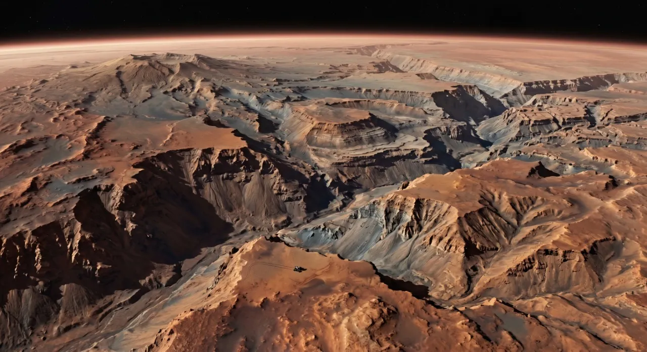
A bird's-eye view of Valles Marineris and, if you squint hard enough, a tiny rover at the edge of the abyss recalculating its route. Google Maps GPS definitely still needs improvement on the Red Planet.
For centuries, astronomical observation viewed Mars as a fossil world, a static and geologically simplistic sphere that had remained unchanged since the dawn of the Solar System. However, the arrival of space exploration in the second half of the twentieth century shattered this paradigm. In the annals of science, few structures have challenged our notions of planetary geodynamics as much as the majestic canyon system of Valles Marineris. Discovered by the Mariner 9 orbital probe during its historic mission between nineteen seventy-one and nineteen seventy-two, this monumental equatorial incision extends for more than four thousand kilometers in length, spanning approximately one-fifth of the total circumference of the Red Planet. Its existence raises a fundamental question for modern geology: how could a planet notably smaller than Earth harbor the deepest and most colossal tectonic fracture among the rocky worlds?
Comparative physiography: the Martian abyss in the terrestrial mirror
To help our minds grasp the true dimensions of Valles Marineris, comparative geology routinely turns to an old acquaintance on Earth: the Grand Canyon of the Colorado in Arizona. However, when juxtaposing both landforms, the comparison immediately transforms into an exercise in astonishment. The terrestrial Grand Canyon is a purely erosive feature, patiently sculpted by the persistent flow of the Colorado River over about six million years. With its respectable four hundred and forty-six kilometers in length, thirty kilometers in width, and just under two kilometers in depth, it represents one of the greatest natural wonders of our world. In contrast, Valles Marineris is an immense scar of predominantly structural and tectonic origin. Its numbers defy human scale: it reaches a length of up to four thousand five hundred kilometers —the equivalent of crossing the entire territory of the United States horizontally—, a width of six hundred kilometers in its central sectors, and a vertical abyss that plummets down to eleven kilometers in depth.
This abyssal depth is sustainable on Mars due to a key geophysical characteristic: the planet's lower gravity, which equals thirty-seven percent of Earth's. This property drastically reduces the shear stress on the canyon walls, allowing the stability of vertical cliffs several kilometers high in a way that would be physically impossible on Earth. If we attempted to open a trench ten kilometers deep in the Earth's crust, the colossus would immediately collapse upon its own base. Our planet's high gravity and its elevated internal thermal gradient would cause the bottom rocks to behave plastically, sealing the fracture as if it were warm modeling clay. Curiously, thanks to data collected by precision instruments such as the MOLA laser altimeter on the Mars Global Surveyor probe and the HRSC camera on Mars Express, we now know that the lowest elevations of the Martian canyon lie nearly six kilometers below the global mean level, forming a unique window into the deep entrails of the planet.
A journey through the chasmata: the anatomy of the giant
Valles Marineris does not present itself to the observer as a uniform linear trench, but rather as a complex segmented network of colossal valleys known individually as chasmata. From west to east, the system displays a geomorphological zonation that tells a fascinating tale: from pure magmatic activity to the catastrophic release of subsurface fluids. At the westernmost end, we encounter Noctis Labyrinthus, the labyrinth of the night. This fascinating geological province forms an orthogonal network of narrow valleys and flat mesas that extends for about one thousand two hundred kilometers. Imagine the crust of a planet stretching and cracking in multiple directions under colossal stresses, causing blocks of rock to drop along normal faults. High-resolution spectral analysis inside the troughs of Noctis Labyrinthus has revealed the presence of gypsum and other evaporites in light-toned deposits. These formations suggest chemical dissolution processes that would have been fostered by the seasonal melting of ice during eras of high planetary obliquity, demonstrating that liquid water persisted in protected subsurface microclimates during recent periods.
Moving eastward, the labyrinth merges into colossal and deep depressions that expose thick stratigraphic sequences. Here, Ius and Tithonium Chasma open up, two parallel troughs whose slopes exhibit the scars of groundwater aquifer sapping. Right after, Melas Chasma opens, the widest and deepest sector of the central province, where hydrated sulfates stable in its bed support the hypothesis of ancient permanent lakes during the Hesperian period. Adjacent to this colossus lie Candor and Ophir Chasma, which contain deep interior layered deposits. These formations consist of regular layers of sedimented volcanic ash or lacustrine deposits accumulated in quiet water environments, behaving like the pages of a textbook that record the climate of the Martian past. An exceptional case is represented by Hebes Chasma, a completely closed and isolated trough from the main system. In its geometric center rises Hebes Mensa, an imposing five-kilometer-high mesa that exhibits an intact stratigraphic pile, standing as a monument to regional sedimentary deposition.
Finally, the eastern terminus branches into Ganges, Capri, and Eos Chasma. In this region, the linear tectonic morphology of parallel faults completely vanishes to give way to the so-called chaotic terrains. These dense clusters of collapsed blocks and eroded knobs originated when liquid water confined under pressure in the cryosphere broke violently toward the surface. The release of this massive volume of water triggered catastrophic floods toward the north, carving gigantic outflow channels that emptied into the Chryse basin. Examples of this dynamism are Echus Chasma, the source of the immense Kasei Valles flood channel, and Juventae Chasma, an isolated trough that gave rise to the Maja Valles overflow channel, confirming that fluid release was a process of planetary scale.
Conflicting geodynamic models: how did the crust rip?
The formation of Valles Marineris has been the subject of intense scientific debate since the dawn of the space age. Old hypotheses from the seventies that attributed the canyon exclusively to water erosion or collapse from permafrost melting have been discarded. In a world with such a thin atmosphere —barely one percent of Earth's atmospheric pressure— and frigid temperatures, it is physically unfeasible to maintain stable continuous flows of liquid water on the surface without it instantly evaporating or freezing. The most widely accepted theory today links the birth of the canyon to the volcanic bulge of Tharsis, an immense crustal uplift located west of the structure. During the Noachian and Hesperian periods, the ascent of a mantle superplume loaded the Martian lithosphere with tons of basaltic lava. As isostatic equilibrium was lost, the enormous volcanic mass generated brutal lithospheric flexural stresses, triggering a pattern of radial fractures that opened the primordial tectonic troughs of Valles Marineris.
To visualize this phenomenon, we can imagine the Martian crust not as a rigid and brittle stone countertop, but rather as a large sheet of pastry dough that bends and ripples under pressure until it cracks. An analogous example of this flexural cracking is observed in Acheron Fossae, north of Tharsis, where dozens of curved normal faults slice the terrain. However, in two thousand twelve, geologist An Yin introduced a revolutionary perspective by proposing that Valles Marineris is actually a tectonic plate boundary characterized by a strike-slip fault with net horizontal displacement. By analyzing high-resolution thermal images, Yin documented a net horizontal displacement of approximately one hundred and fifty kilometers in key regional structures, such as ancient impact craters sliced cleanly in half. The exceptional straightness of the canyon's trace —especially in Coprates Chasma— immediately evokes Earth's great transform faults, such as the San Andreas Fault. According to this model, Mars experienced a primitive and interrupted stage of local plate tectonics that covered a quarter of the planet, but which stopped due to the rapid internal cooling of the planet.
As a complementary hypothesis, the theory of collapse due to magma withdrawal and karstification is gaining ground. Several researchers propose that the immense empty cavity of the canyon was initially generated when large underground magma chambers were siphoned westward to feed the Tharsis volcanoes, leaving behind immense empty caverns that collapsed under the weight of the overlying basalts. In parallel, during the Noachian period, a thick atmosphere rich in carbon dioxide would have favored the formation of carbonate rocks in the crust. The subsequent ascent of acidic hydrothermal fluids —rich in sulfur compounds generated by volcanism— chemically dissolved these horizons, generating colossal voids that led to large-scale gravitational collapse.
Erosion, glaciers, and lubricated landslides
Despite its tectonic cradle, the modern landscape of Valles Marineris has been profoundly remodeled by exogenic processes. One of the most fascinating findings is the presence of jarosite deposits on the mid-slopes of the cliffs, at more than five kilometers in altitude. The existence of this hydrated iron sulfate rules out the presence of ancient permanent lakes at those elevations, since maintaining pools of liquid water suspended on vertical walls defies the laws of physics. Instead, the geological context points to the action of ancient glaciers. Stable ice masses accumulated on cold slopes chemically reacted with volcanic atmospheric dust rich in sulfur, precipitating the mineral at the interface between ice and rock. The abrasion caused by the slow flow of these ice masses helped carve the characteristic U-shaped profiles observed in tributary canyons.
Likewise, on the southern margin of the canyon, in areas such as Louros Valles, dense networks of tributary valleys with semicircular amphitheater-shaped heads are visible. These landforms are the direct result of groundwater sapping. Water contained in deep aquifers leaked outward where faults cut the crust, surfacing on the walls as springs. This constant flow mechanically eroded the base of the basaltic cliffs, destabilizing the upper layers which eventually collapsed, allowing the tributaries to advance kilometers into the surrounding mesas. After the cessation of major tectonic stresses, the gravitational instability of ten-kilometer-high walls triggered colossal landslides that laterally widened the system.
Many of these Martian landslides exhibit extreme horizontal runout distances of up to hundred kilometers along the flat canyon floor. To evaluate the physics of these displacements, scientists study the apparent coefficient of friction, defined as the ratio between the vertical drop height and the maximum horizontal displacement. While in terrestrial dry-rock landslides this coefficient hovers around high values, in Valles Marineris the avalanches show exceptionally low values. This drastic reduction in internal friction demonstrates the intervention of a highly efficient basal lubrication process that allowed the debris to behave as viscous fluids at speeds exceeding hundred kilometers per hour. Curiously, the geomorphological analysis of longitudinal striations on the debris surface supports the hypothesis that these colossal landslides slid over subsurface ice cushions or wet evaporite beds, triggered by marsquakes associated with Tharsis volcanism.
A living world: seasonal lines and the hidden titan
Mars is not a geophysically dead desert. High-definition observations made in recent decades reveal that Valles Marineris remains a dynamic environment. An indisputable example is the Recurring Slope Lineae, subtle dark narrow bands of low reflectance observed on the steep walls of Melas and Coprates Chasma. These structures display a markedly seasonal behavior: they appear and lengthen downslope during the Martian spring and summer, when surface temperatures exceed local freezing points, and gradually fade away during autumn and winter. Infrared spectroscopy captured by the Mars Reconnaissance Orbiter demonstrated the presence of hydrated salts that match these lines spatially and temporally. These salts act as a natural antifreeze, lowering the freezing point of water and allowing liquid brines to exist. The most solid hypothesis links these lines to the seasonal discharge of deep saline aquifers traveling through the tectonic fractures of the canyon walls.
As if that were not enough, the region surprised us with the spectacular announcement of the discovery of a deeply eroded giant shield volcano: Noctis Mons. Located right at the transition boundary between Noctis Labyrinthus and western Valles Marineris, this colossal structure reaches an altitude of more than nine thousand meters and a base that extends up to four hundred and fifty kilometers in diameter. The volcano had remained hidden from the eyes of science for more than fifty years due to its advanced state of erosive dismantling by water, tectonic faulting, and glaciation, which completely blurred its classic conical silhouette. On its lower slopes, fields of rootless cones have been identified, landforms identical to those observed in Iceland that originate when fluid lava flows suddenly cover ground saturated with water or ice, causing explosive vaporization.
Even more fascinating is the discovery on the southeastern flank of Noctis Mons of a relict glacier buried beneath a thermally insulating mantle of volcanic ash just a few meters thick. This thin protective layer acts as a natural thermos, preventing the ice from sublimating into outer space in a thermally benign equatorial zone. Given that the magmatic history of this volcano extends from three thousand seven hundred million years ago to pyroclastic episodes just ten million years ago, Noctis Mons represents a persistent thermal anomaly. The astrobiological implications are revolutionary: the continuous interaction of hot magma with ice masses would have sustained stable hydrothermal pockets of warm mineral-rich water for billions of years, offering the ideal ecological niche for the development and survival of endolithic microbial communities in the Martian subsurface.
Reflections for the future of humanity
Valles Marineris is much more than a geological marvel; it is the great three-dimensional archive of the history of Mars. Its vertical walls expose before our eyes billions of years of planetary evolution, from the primitive volcanism of the Noachian to the hyperaridity of the Amazonian, passing through the catastrophic floods of the Hesperian. For humanity, this colossal abyss represents the ultimate frontier of space exploration and astrobiology. The documented coexistence of persistent geothermal heat sources, protected glacial water resources beneath the regolith, and seasonal brines makes this canyon the optimal enclave to search for biosignatures of past or present extraterrestrial life. Likewise, its equatorial latitudes offer an ideal thermal refuge for future human settlements, where the canyon walls could provide natural protection against cosmic radiation. When the first explorers step onto the floor of Melas Chasma and gaze at the cliffs rising ten kilometers above their heads, they will understand that real science far surpasses the boldest of fictions.