Ingenuity
The Ingenuity helicopter validated controlled flight in the thin Martian atmosphere by completing 72 autonomous missions over three years. Its visual-inertial navigation system suffered a fatal loss of optical flow over uniform dunes during Flight 72, causing horizontal drift and a terminal impact that fractured its rotors.
Agency
Country

Type
Helicopter
Status
Launch
July 30, 2020
COSPAR Designation: 2020-052E
Official Names: Ingenuity Mars Helicopter (Mars 2020)
Responsible Space Agency: NASA / Jet Propulsion Laboratory (JPL)
Launch Date and Time: July 30, 2020, 11:50 UTC
Landing Date and Time (EDL): February 18, 2021, 20:55 UTC
Landing Location: Jezero Crater, Mars (Coordinates: 18.38° N, 77.58° E)
Launch Vehicle: Atlas V 541
Current Mission Status: Concluded (End of operations due to irreversible rotor structural damage during Flight 72)
1. Historical Context and Detailed Objectives
The exploration of the planet Mars has traditionally been limited to static surface platforms or wheeled vehicles constrained by terrain topography. The Ingenuity Mars Helicopter mission was conceived as a high-risk technology demonstration to fill a critical operational void: the validation of controlled, powered flight in an extremely thin atmosphere. The primary objective of the mission was purely engineering-focused, aiming to prove the viability of aerodynamic lift and flight autonomy under Martian environmental conditions during an initial 30-sol window.
Following the success of the demonstration phase, secondary objectives evolved toward operational support. The vehicle assumed the role of an advanced scout for the Perseverance rover, mapping safe passages across the Jezero Crater river delta, evaluating the trafficability of dune fields, and locating scientific targets of geochemical interest that were inaccessible to ground-based platforms. Thus, a proof of concept was transformed into a tactical aerial exploration tool.
2. Vehicle Architecture and Primary Subsystems
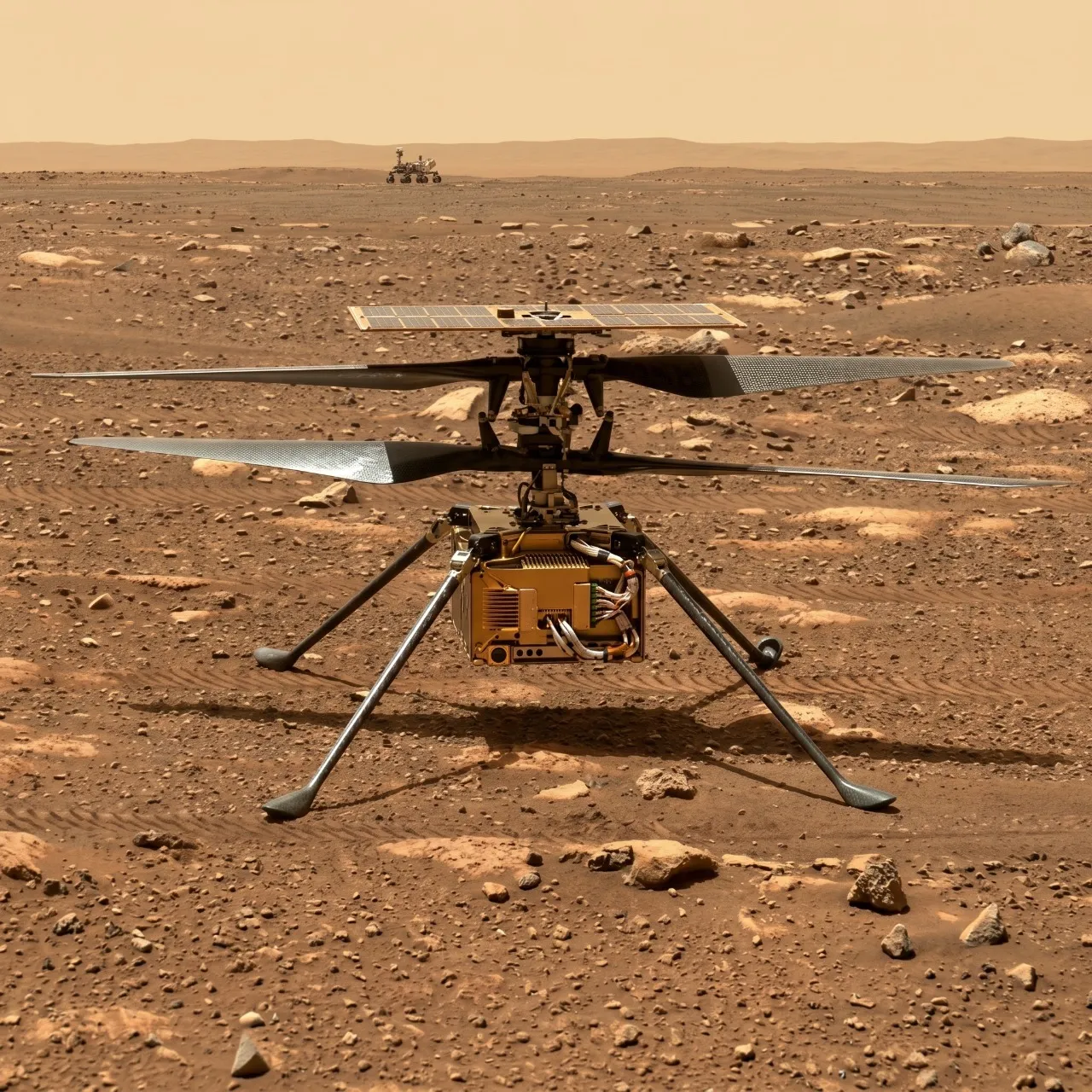
The Ingenuity space platform features a total mass of 1.8 kilograms and an effective weight on Mars of 0.68 kilograms due to the lower acceleration of gravity. The propulsion system utilizes two direct-drive brushless direct-current motors. Thermal control is critical for nocturnal survival; it relies on vacuum insulation via a composite fuselage shell and internal electric heaters that mitigate extreme thermal drops in the Martian environment. The power generation wattage depends on a gallium arsenide solar panel mounted above the rotor shaft, capable of providing specific peak loads to feed the battery system.
Attitude control is executed through the rapid modification of the collective and cyclic pitch of the rotors via servoactuadores at a high refresh frequency. The telecommunications subsystem relies on a low-power transceiver operating in the 900 megahertz ISM band, communicating with the base station aboard the rover. The real-time data transfer bit rate during flight phases reaches 200 kilobits per second, autonomously descending to 10 kilobits per second on the ground if signal attenuation or distance compromises the wireless link margin.
3. Payload and Scientific Instrumentation
Due to its nature as a technology demonstrator, the payload was strictly optimized for navigation and visual documentation, omitting mass spectrometers or heavy analytical tools. The onboard instrumentation is detailed below:
Monochrome Navigation Camera (OV7251)
This global shutter optical sensor operates in the visible spectrum, capturing images at a 640 by 480-pixel resolution at a constant rate of 30 hertz. Its physical principle is based on measuring the optical flow of the terrain to calculate the relative velocity of the vehicle. To understand its operation, it is similar to how the optical sensor of a desktop computer mouse detects microtextures on a desk to move the cursor precisely on the screen.
Detection range: Monochrome visible spectrum.
Manufacturer: OmniVision Technologies.
Purpose: Supplying real-time visual data to the Kalman filter for state estimation and closed-loop visual-inertial odometry.
High-Resolution Color Camera (RTE)
This is a high-definition sensor with a resolution of 13 megapixels that acquires color images with a horizon-facing field of view or an oblique downward perspective.
Detection range: Standard RGB visible spectrum.
Manufacturer: Sony.
Purpose: Capturing terrain reconnaissance data for rover route planning and high-spatial-resolution geological documentation.
Laser Altimeter Sensor (Lidar-Lite-V3)
This instrument bases its operation on emitting short-wave infrared pulses and measuring the time it takes for the light to bounce off the Martian surface and return to the receiver.
Detection range: Vertical distances from 0.5 meters up to an operational limit of 40 meters.
Manufacturer: Garmin.
Purpose: Providing relative altitude measurements with respect to the ground at a frequency of 50 hertz to feed the external vertical flight control loop.
4. Launch Vehicle and Flight Profile / EDL
Ingenuity was launched as an integrated payload attached to the underside of the Perseverance rover chassis aboard an Atlas V 541 launch vehicle. The injection into a heliocentric transfer orbit toward Mars was executed nominally following the separation of the Centaur upper stage. During the seven-month interplanetary cruise, the helicopter depended entirely on power supplied by the rover to maintain its battery temperature within safe storage ranges.
The Entry, Descent, and Landing (EDL) sequence was executed under the direct management of Perseverance on February 18, 2021. Following aerodynamic deceleration via the heat shield in the upper atmosphere at hypersonic velocities exceeding Mach 20, the supersonic parachute was deployed. The Sky Crane system performed the final descent maneuver via retro-propulsion, depositing the rover and the attached helicopter inside Jezero Crater at zero vertical velocity. Ingenuity remained protected by a graphite debris shield until its subsequent mechanical deployment onto the Martian surface weeks later.
5. Operational Development and Scientific Results
The operational campaign on Mars unexpectedly extended across 72 autonomous aerial missions over nearly three Earth years. During the Martian winter phase, the vehicle experienced severe deficiencies in its electrical state of charge due to dust accumulation on the solar panel and reduced irradiance. The lack of nocturnal power caused widespread brownouts that misaligned the internal clock of the main processor, interrupting daily communications synchronization with the rover. This thermal issue subjected the COTS avionics to continuous extreme freezing cycles down to minus 80 degrees Celsius, accelerating material fatigue.
Despite these constraints, operational results yielded high-value empirical data on Martian atmospheric dynamics, mapping local wind profiles and measuring seasonal gas density variations at ground level. The cameras documented the presence of laminated sedimentary formations rich in clays and carbonates in the Jezero Crater delta, verifying the stability of the primitive riverbed. The end of the mission occurred during Flight 72 on January 18, 2024. While flying over a uniform, rock-free sand dune, the MaVEN navigation algorithm suffered a massive loss of optical flow due to a lack of visual contrasts. Relying solely on inertial integration, the vehicle accumulated an undetected horizontal drift velocity. Upon an inclined touchdown, the violent dynamic coupling caused asymmetric flexing and a blade-to-blade collision of the counter-rotating rotors at 2,700 revolutions per minute, irreversibly fracturing the carbon fiber tips of the blades.
6. Conclusion and Technical Legacy
Ingenuity surpassed pre-established aeronautical design limits, redefining the paradigms of planetary exploration in thin atmospheres. The free-flight validation of commercial electronic components with high processing capacity opened the doors to lower-cost missions with higher algorithmic performance. The technical legacy of the mission serves as a direct foundation for the designs of the Sample Recovery Helicopters (SRH), which will incorporate wheels and lightweight articulated arms, and for the Mars Science Helicopter (MSH) concept, a larger-mass hexacopter platform capable of transporting complex analytical instruments to inaccessible regions of the Martian geography.
Mission Milestones
Launch
SOL 36 OF PHOBO OF YEAR 35
203 days (~197 sols)
of travel
Arrival at Mars
SOL 11 OF ACIDALO OF YEAR 36
Operations Start
SOL 17 OF CURIOSO OF YEAR 36
998 sols
of operations